2 LPAs develop into Tropical Depressions Butchoy, Carina
MANILA, Philippines — The two low pressure areas (LPAs) inside the Philippine Area of Responsibility (PAR) both developed into tropical depressions on Friday night, state weather bureau PAGASA reported.
The tropical cyclones have been given the name "Butchoy" and "Carina."
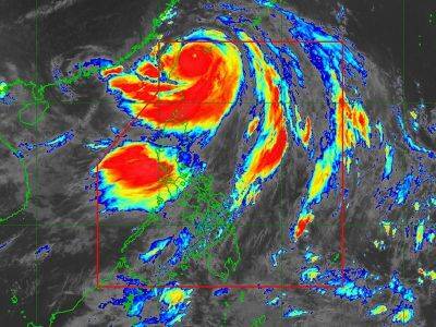
In its 11 p.m. weather bulletin, PAGASA said that Tropical Depression Butchoy was last located 535 kilometers west of Tanauan City, Batangas, with maximum sustained winds of 55 kilometers per hour near the center, gustiness of up to 70 kph as it moves eastward at 25 kph.
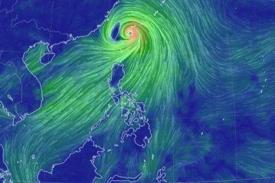
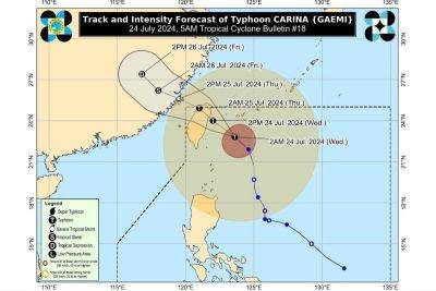
Meanwhile, Tropical Depression Carina was last spotted 780 kilometers east of Virac, Catanduanes, carrying maximum sustained winds of 45 kph with gustiness of up to 55 kph while moving west northwest at 20 kph.
Both Tropical Depressions Butchoy and Carina will have minimal to no impact on Saturday.
"Butchoy is unlikely to directly affect the country within the next three days," PAGASA said.
According to the state weather agency, heavy rainfall directly caused by Carina "remains less likely over next three days."
While the tropical depressions may not hit land, both are expected to intensify over the weekend.
Butchoy may become a tropical storm by Saturday, though it is expected to exit the Philippine Area of Responsibility (PAR) by Saturday morning.
Carina is expected to gradually intensify, becoming a tropical storm by Sunday and further strengthening to reach the typhoon category on Tuesday.
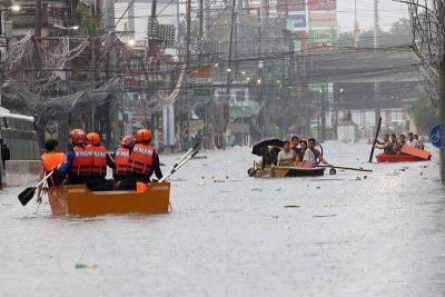
The southwest monsoon or habagat, enhanced by Butchoy and Carina, will bring moderate to heavy rains to the western part of Luzon over the next three days and cause gusty conditions in the Kalayaan Islands.
Antique, Palawan, Occidental Mindoro, Zambales and Bataan will experience cloudy skies with scattered rain showers and thunderstorms due to the southwest monsoon. Moderate to heavy rains may lead to flash floods or landslides in these areas.
Mindanao, the rest of the Visayas, and MIMAROPA will have partly cloudy to cloudy skies with isolated rain showers or thunderstorms caused by the southwest monsoon. Severe thunderstorms in these regions may lead to flash floods or landslides.
Metro Manila and the rest of Luzon are expected to see
Related News