‘Carina’ floods parts of Metro, continues to move away from PH
BY VICTOR REYES and ASHZEL HACHERO
BATANES has been placed under Signal No. 2 due to typhoon “Carina” which continued to move away from the Philippine landmass towards Taiwan where it is forecast to make landfall today or tomorrow.
Four other areas are under Signal No. 1 — namely Cagayan including Babuyan Islands, eastern portion of Isabela, northern portion of Apayao, and northern portion of Ilocos Norte.
The Philippine Atmospheric, Geophysical and Astronomical Services Administration (PAGASA threat to life and property for areas under Signal No. 2 was “minor to moderate” and “minimal to minor” for areas under Signal No. 1.
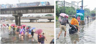
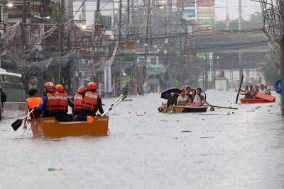
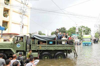
Rains from Carina and the southwest monsoon caused flooding in several areas in Metro Manila, and prompted the Metropolitan Manila Development Authority to suspend the implementation of the Unified Vehicular Volume Reduction Program, or “number coding scheme” yesterday afternoon.
The MMDA’s Pasig River Ferry Service also suspended operations yesterday.
Malacañang suspended work in government offices and classes in all levels in both public and private schools in Metro Manila due to the continued rains.
As of 4 p.m. yesterday, Carina was some 325 km east northeast of Basco, Batanes, PAGASA said in its bulletin issued at 5 p.m. yesterday.
Carina was packing maximum sustained winds of 150 kph near the center and gustiness of up to 185 kph. It was moving northward at 20 kph.
“On the track forecast, Carina will remain far from the Philippine landmass,” PAGASA said.
“It is also forecast to make landfall over the northern portion of Taiwan between tomorrow (Wednesday) evening (or) Thursday morning, then exit the Philippine area of responsibility (PAR) hours later,” added PAGASA.
PAGASA said Carina will cross the Taiwan Strait and make another landfall in southeastern China on Thursday afternoon or evening.
“Carina is forecast to steadily intensify and may reach its peak intensity prior to its landfall over Taiwan due to favorable environment. Rapid intensification remains likely,” it said.
PAGASA said Carina will continue to bring rains in areas in northern Luzon, specifically in Batanes, Cagayan, Ilocos sur, Ilocos Norte, La Union, Abra, Benguet,
Related News