LPA leaves PAR, develops into tropical depression
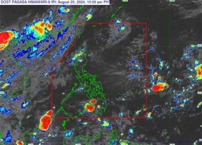
MANILA, Philippines — The low-pressure area inside the Philippine area of responsibility has left as it developed into a tropical depression outside PAR, the Philippine Atmospheric, Geophysical and Astronomical Services Administration (PAGASA) said yesterday.
At a 4 p.m. briefing, PAGASA weather specialist Veronica Torres said the tropical cyclone outside PAR was located 1,520 kilometers east-northeast of extreme Northern Luzon with maximum sustained winds of 45 kilometers per hour and gustiness of up to 55 kph. It is moving northeast at 19 kph.
“This tropical depression has no direct effect on any part of the country,” Torres added.
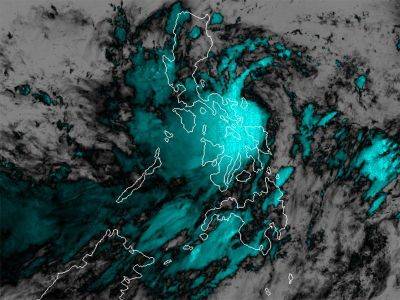
The southwest monsoon continues to affect Luzon and the Visayas, according to the weather specialist.
“We expect rains in the Ilocos region, Batanes, Babuyan Islands and Zambales. We advise our citizens in affected areas to take the necessary precaution amid the threat of flooding and landslides,” Torres said.
PAGASA said the southwest monsoon would also bring rains in Metro Manila, the rest of Luzon, Western Visayas and Negros Island Region.
The rest of the country will experience localized thunderstorms.
PAGASA administrator Nathaniel Servando said that up to three tropical cyclones might develop within the Philippine area of responsibility this August.
“The rainfall forecast for the month suggests near-normal conditions over the country, except for Misamis Oriental and Agusan del Norte in Mindanao, which are expected to experience above-normal rainfall conditions.
The probabilistic forecast also shows that most parts of the country will likely receive near to above-normal rainfall,” Servando added.
He noted that La Niña “increases the likelihood of having above-normal rainfall conditions, which could lead to potential adverse impacts such as heavy rainfall, floods, flash floods and rain-induced landslides over highly vulnerable areas.”
Citing global climate models, Servando said there is a 70-percent probability of La Niña emerging between this month and October.