Batanes under Signal No. 3 as Jenny heads for Taiwan
Tropical Cyclone Wind Signal (TCWS) No. 3 has been hoisted over the
province of Batanes as Typhoon Jenny is about to exit the Philippine
Area of Responsibility, the weather bureau said Thursday.
Moderate to significant impacts from storm-force winds may be
experienced over Batanes.
TCWS No. 2 remains hoisted over the northern portion of Babuyan
Islands, while TCWS No. 1 has been hoisted over the rest of the
Babuyan Islands, the northern portion of mainland Cagayan (Santa Ana,
Gonzaga, Buguey, Santa Teresita, Lal-Lo, Camalaniugan, Pamplona,
Claveria, Aparri, Ballesteros, Abulug, Allacapan, Sanchez-Mira, Santa
Praxedes, Lasam, and Gattaran), the northern portion of Apayao
(Calanasan, Pudtol, Luna, Santa Marcela, and Flora), and the northern
portion of Ilocos Norte (Piddig, Bangui, Vintar, Burgos, Pagudpud,
Bacarra, Adams, Pasuquin, Carasi, Dumalneg, and Laoag City).
Gale-force winds will prevail over areas under TCWS No. 2, and strong
winds are likely to prevail in areas under Signal No. 1.
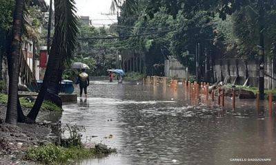
Gusty conditions will be experienced over the southern portion of
Aurora, Romblon, and portions of Calabarzon, Metro Manila, Bataan, and
Bicol Region as Jenny enhances the southwest monsoon.
Occasional rains may be experienced over the western portion of Luzon.
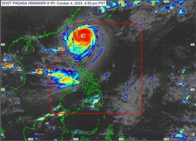
Jenny, packing maximum sustained winds of 175 kph near the center and
gustiness of up to 215 kph, was last tracked 140 km. north-northwest
of Itbayat, Batanes.
The Philippine Atmospheric, Geophysical and Astronomical Services
Administration (PAGASA) said Jenny could make landfall over the
southern portion of Taiwan on Thursday morning and exit the PAR
between afternoon and evening.
Meanwhile, rough to very rough seas will prevail over the seaboards of
Northern Luzon.
“Sea travel is risky for vessels of any type or tonnage. All mariners
must remain in port or, if underway, seek shelter or safe harbor as
soon as possible until winds and waves subside,” PAGASA said.
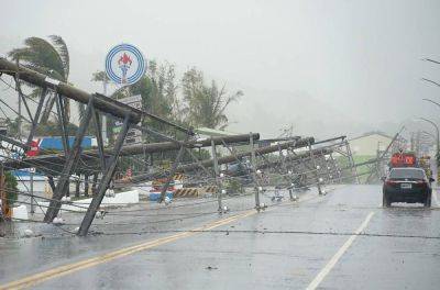
Minimal damage so far
The National Disaster Risk Reduction and Management Council (NDRRMC),
meanwhile, reported minimal damage over the regions affected by the
typhoon.
In its update, the NDRRMC also reported only 29 affected families,
equivalent to 275 persons,