EDITORIAL - Sea squatters
The Philippines has centuries-old maps prepared and recognized by other countries, defining its terrestrial territory on which its maritime domain and economic entitlements are calculated. The United Nations Convention on the Law of the Sea or UNCLOS defines the boundaries for maritime sovereign rights and entitlements: a 200-nautical-mile exclusive economic zone from the coastline.
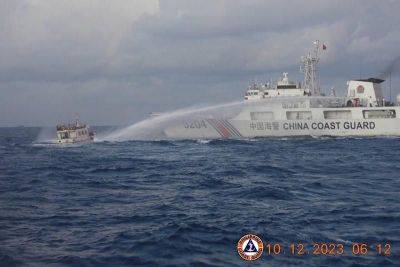
Both the Philippines and China have ratified UNCLOS. Based on this UN convention, the Philippines asked the Permanent Court of Arbitration in The Hague to define the country’s maritime entitlements, after China took over Panatag or Scarborough Shoal in Zambales and drove away Filipinos from their traditional fishing ground.
Panatag lies 124 nautical miles from the Zambales town of Masinloc, and approximately 472 NM from the southernmost coast of China. Ancient maps identify Panatag as the shoal of Masinloc or Bajo de Masinloc. It was named after the British ship Scarborough, which ran aground on the shoal on Sept. 12, 1748.
The arbitral court, whose proceedings were snubbed by China, ruled in 2016 in favor of the Philippines, and invalidated Beijing’s expansive nine-dash-line claim over nearly the entire South China Sea. The court specifically declared that the Philippines has sovereign rights over Panganiban (Mischief) Reef off Palawan, Ayungin (Second Thomas) Shoal and Recto (Reed) Bank.
The court ruling clearly does not recognize artificial islands built to expand maritime claims – something which China has been doing for several years now in an attempt to extend its landmass as if it wasn’t already massive enough. It has been squatting on Panganiban Reef, building an artificial island through deceit by initially claiming that huts it initially installed on the corals about three decades ago were merely shelters for fishermen. The “shelters” have since grown into a multistory concrete structure sitting on what is now a militarized fake island.
The Philippines has all the right, recognized under international rules, to move around freely within its 200-nautical-mile EEZ, which includes Panganiban, Ayungin and Panatag. What has China got to show to support its greedy maritime claim,