More Visayas, Mindanao areas under Signal No. 1 due to ‘Kabayan’
MANILA, Philippines — More areas in Visayas and Mindanao were placed under Wind Signal Number 1 as Tropical Depression Kabayan moved closer to the Philippine landmass, the country’s weather agency said Sunday afternoon.
Kabayan, the country’s 11th cyclone this year, was last spotted 385 kilometers east of Davao City in Davao del Sur or 315 km east southeast of Hinatuan in Surigao del Sur.
The tropical depression maintained its peak winds of 55 km per hour and gusts of up to 70 kph.
Moving west slowly, Kabayan may make landfall along the coast of Surigao del Sur or Davao Oriental Sunday evening or early Monday.
PAGASA placed the following areas under Wind Signal Number 1:
The weather agency warned that “minimal to minor impacts from strong winds” are possible in any of the areas under Wind Signal Number 1.
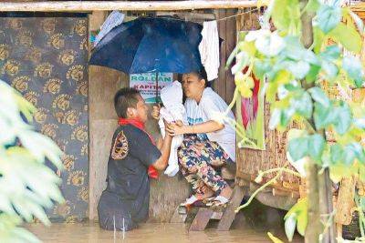
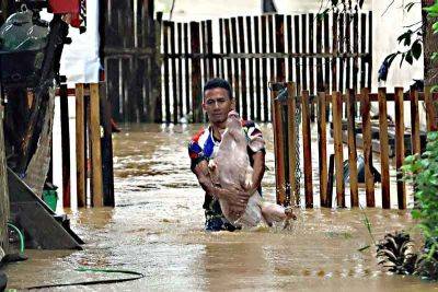
According to PAGASA, Kabayan will dump heavy rain to parts of Visayas and Mindanao.
Surigao del Sur, Surigao del Norte, Dinagat Islands and Southern Leyte are expected to receive an accumulated rainfall of 100 to 200 millimeters until Monday afternoon.
Meanwhile, Eastern Visayas, Davao region, Northern Mindanao, and the rest of Caraga will have an accumulated rainfall ranging between 50 and 100 mm.
Rainfall is expected to be higher in mountainous areas. This may result in flooding and landslides, particularly in areas highly susceptible to these hazards and those that have experienced significant rainfall in recent days.
The shear line, a weather system formed when cold and warm winds converge, may also bring heavy rainfall to the eastern portion of southern Luzon Sunday and the eastern portion of Luzon Monday.
PAGASA added the surge of northeast monsoon or amihan will also bring gusty conditions for the next two days to the following areas not under any wind signal, especially in coastal and upland areas:
Once it makes landfall in Mindanao, Kabayan is forecast to cross the area’s rugged terrain and emerge over Bohol Sea or Sulu Sea Monday morning or afternoon.
PAGASA said that Kabayan is forecast to weaken over land after landfall and the possibility of being downgraded into a low pressure area is not ruled out. In such a case, however, redevelopment
Related News