PAGASA forecast: ‘Carina’ to intensify into a typhoon
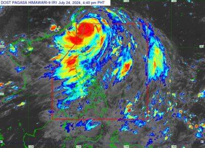
TROPICAL depression “Carina” is forecast to intensify into a typhoon but will remain far from the Philippine landmass, the Philippine Atmospheric, Geophysical and Astronomical Services Administration (PAGASA) yesterday said.
In a bulletin issued at 5 p.m. yesterday, PAGASA said Carina was some 365 kilometers east of Casiguran, Aurora as of 4 p.m. Sunday.
It said Carina is almost stationary even and packing maximum sustained winds of 85 kph near the center and gustiness of up to 115 kph.
PAGASA said Carina is forecast to “steadily intensify over the next four days due to favorable environment” and is expected to bring rains in Cagayan, Isabela and Batanes.
“It is forecast to become a severe tropical storm by tonight (Sunday night) and reach typhoon category tomorrow (Monday) evening. Rapid intensification within the forecast period is possible,” it added.
The weather bureau did not rule out the possibility of hoisting wind signal No. 1 over extreme northern Luzon and the northeastern portion of mainland Cagayan last night or today “in anticipation of strong winds associated with Carina.”
PAGASA said Carina is also enhancing the southwest monsoon, bringing rains in the western portion of Luzon.
PAGASA said that “over the Philippine Sea, Carina is forecast to move generally north-northwestward to northward from (Sunday) until Tuesday.”
“On the track forecast, Carina will remain far from the Philippine landmass and exit the Philippine Area of Responsibility on Wednesday night or Thursday early morning while moving near the islands in the Ryukyu archipelago,” the weather bureau said.
Once outside the PAR, Carina is forecast to turn generally northwestward on Thursday over the East China Sea.
Carina and “Butchoy” are the third and second tropical cyclones to hit the country this year, respectively. They developed into a tropical depression last Friday, though Butchoy exited the Philippine Area of Responsibility (PAR) on Saturday.
GOVT AID
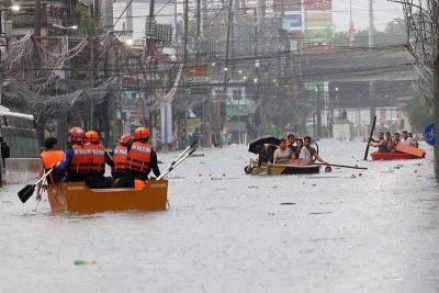
The Department of Social Welfare and Development (DSWD) yesterday said more than P3 million worth of food and non-food relief items have been provided to 17,236 families or 68,248 persons who were affected by Butchoy from 119
Related News